Geospatial Systems

Advancing Wildfire Research Through LiDAR Technology
The increasing frequency of extreme natural disasters such as wildfires and flooding throughout California and beyond is driving the need for innovative methods to assess and reduce risks. A new, multidisciplinary lab at Cal Poly is using advanced geospatial technology to find ways to meet those needs.
The Geospatial Systems Lab at Cal Poly, launched by Professor Marc Horney, whose research is focused on rangeland ecology and management, uses LiDAR (light detection and ranging) technology to scan complex, living landscapes and render them into virtual three- dimensional representations of themselves at centimeter scales. Right now, the lab team is particularly focusing on fire-prone ecosystems along the Central Coast.
"We are leveraging high-resolution remote sensing to advance environmental science," Horney said. "In the lab we have faculty and students from every college on campus with more than 15 majors represented working on research. That is the type of collaboration that is needed to solve problems as big as the ones we are facing."
Research areas include fire and fuels behavior, ecosystem composition, landscape-level biomass estimation, watershed management and multi-temporal terrain modeling. One such project was recently done for the city of San Luis Obispo to map potential creek obstructions in an effort to minimize future flooding. The lab's advanced technology can penetrate below vegetation to the ground to see possible impediments to water flow.
To date, the lab's research team, which includes more than 20 student lab assistants, has covered 1,500 acres of landscape varying from rangeland to forest and has provided more than 200 hours of training in using the advanced remote sensing techniques to students.
CROSS-CAMPUS COLLABORATION
Inspiration for the lab grew from an eight- year collaboration between Cal Poly's Aerospace Engineering Department's Autonomous Flight Lab and faculty and students in the College of Agriculture, Food and Environmental Sciences. Currently funded by the Cal Poly Wildland-Urban Interface (WUI) FIRE Institute, with additional support from the San Luis Obispo County Community Fire Safe Council, the majority of the research being done is fire focused but has many other ecological applications.
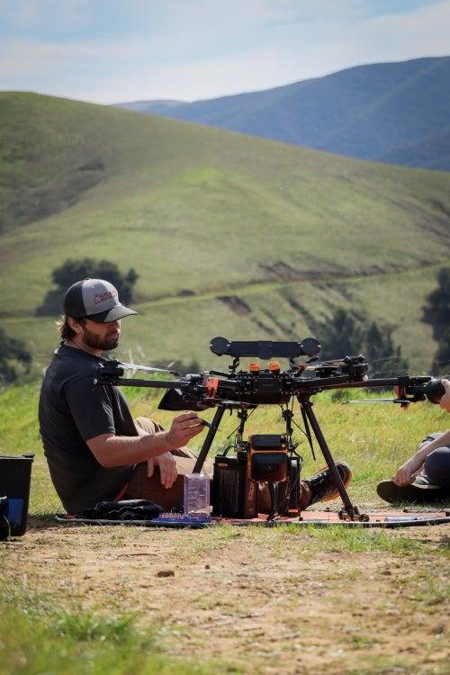
Horney’s most recent partnership with Inspired Flight, a local company manufacturing unmanned aerial vehicles commonly referred to as drones, allows researchers to use sensor systems to gather data that can be applied to improve landscape level vegetation management and fire mitigation measures as a means to improve public safety and ecosystem health. The sensors attached to the aircraft contains a LiDAR (laser scanner) system, a digital camera and a multispectral imager. The laser produces 500,000 pulses per second. Photons from these pulses reflect off objects on the ground below. The system can recover up to five separate reflections from each pulse. If aimed at a tree or a shrub below the aircraft, the first photons in the pulse may reflect off a leaf at the top, the next off a branch within the canopy, after that off the stem below, then off another branch, and finally the last off the soil surface below the plant. A sensor on the scanner records the moment that each reflection returns and uses the position of the aircraft, the direction the beam was pointing and the time that elapsed between the pulse leaving and returning to the laser to pinpoint locations of the objects in a three-dimensional form. A 20-minute flight can easily generate a cloud of over a billion points with this system.
Faculty and students are currently operating this specialty system from two aircraft – the Inspired Flight Technology IF1200 hexacopter and an AeroVironment Vapor-55 electric helicopter. The lab’s student research assistants are also operating professional field survey equipment including two total stations and several GNSS survey systems for establishing precise ground control, necessary for obtaining high levels of precision with the aerial LiDAR sensors. The research opportunities are endless, said Horney. “We are able to use a high resolution camera that uses a multi spectral imager to identify which plants are alive and healthy (doing photosynthesis) and which ones are dead or dying and drying out,” he said. “The LiDAR directly gives us the physical dimensions of vegetation canopies on the land surface below — how tall, how continuous, how dense. Those are valuable metrics to firefighters. Owning this system allows us to re-measure these parameters as often as we like to discover how rapidly these parameters change over time and under different environmental conditions. That’s actually opening a gateway towards some exciting advances in fire ecology and mitigation and management.”
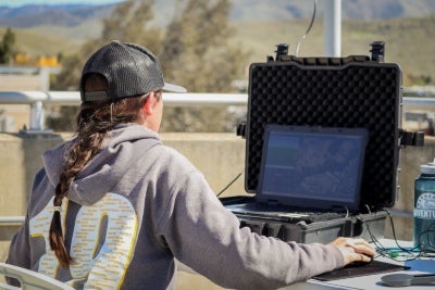
Students in the lab have a wide range of opportunities for hands-on learning. From learning how to earn a commercial remote pilot certification to learning how to fly different aircraft, students are exposed to the latest technology in the field. Students are also immersed in planning aerial surveys, creating and filing mission plans, preprocessing raw LiDAR and survey data and generating large-scale orthoimages from using professional photogrammetry software. Students are also learning how to organize and manage projects, assist with proposal development for project funding and manage and coordinate team activities.
Social sciences Associate Professor Andrew Fricker, who teaches geographic information systems (GIS) courses in Cal Poly’s College of Liberal Arts, spent more than eight years working for non profits, startups and multinational corporations in the commercial mapping and surveying industry and three years working as a researcher at NASA’s Jet Propulsion Laboratory. He assists the project teams in data management.
“Not a lot of universities are doing the work that is happening in Cal Poly’s Geospatial Systems Lab,” Fricker said. “It is new technology and has a lot of different applications across many disciplines and industries. Students are getting early exposure and a really valuable learning opportunity that not a lot of students have access to.”
STUDENTS AT THE FOREFRONT
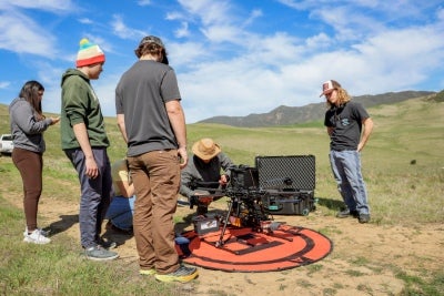
Fourth-year environmental management and protection major Alex Lung has long been fascinated by seeing the world through a different perspective. “I was introduced to geospatial work in my classes and became interested in satellite maps and drone imagery and seeing the world that way,” Lung said, who has assisted in gathering survey points on the ground for the flights done by the research team. “Getting ground control points helps with improving accuracy and with LiDAR you want to be as specific as possible. When fire comes in, it starts low and goes high. In areas that are wooded, you can map the understory and get a clear understanding of what the fuel load looks like.” Lung said the experience he is gaining working with various equipment has furthered his career opportunities. “There will always be technical difficulties when working with equipment in the field and we are learning firsthand how to work through them,” he said.
BioResource and agricultural engineering Lecturer Rudy Schalk has a cadre of students, like Lung, who gather each Friday to learn more about surveying. It is those stude nts who are then trained to do ground control when drone data is collected. “We have specialized surveying equipment to very accurately measure things on the earth,” he said. “By using a GPS satellite network in orbit, we are then able to connect those points of measurement and determine the position of objects on earth within centimeters of their actual location,” he said. “Many of these students have a basic understanding of the process from their class labs, but going out into the real world offers challenges like downed trees, boulders and even rattlesnakes, that you wouldn’t encounter otherwise.”
The total stations used by students can cost upwards of $30,000 each, which means they aren’t often readily available in most programs for students to learn on. “It is a privileged opportunity to work with these stations,” Schalk said. “And because of that, these students have more skills coming out of Cal Poly than most.”
REVOLUTIONIZING WILDFIRE FUEL MANAGEMENT
Madison Muschetto, second-year graduate student in agriculture with a specialization in animal science, is focusing her research on the use of LiDAR and other technology for wildfire fuel classification.
“We are attempting to identify fuels in the landscape at a high resolution and large-scale using LiDAR for pre-fire management,” said Muschetto, who is interested in doing wildland work. “Both of my parents work for CAL FIRE, so fire has always been a big part of my life. I’ve always been interested in fire and the landscape and Dr. Horney provided the opportunity to research in it at a highly technological level.”
Muschetto’s goal is to be able to use geospatial imaging to determine what vegetation exists and its characteristics such as height and density to allow landowners and other decision makers to determine priority areas for treatment. “This data can then be used to set the highest priority based on fuel loading and threat to a population,” she said. “It can be used to pinpoint which areas to focus on and to start there.”
She said the most rewarding part of the work is the opportunity to dive in and learn new skills like drone piloting and mapping with LiDAR. “I’ve been able to work with people from different backgrounds and majors and we continue to teach each other as we go along,” Muschetto said. “It is rewarding to work with a wide variety of people and gain and share knowledge with each other.”
The scope and magnitude of what can be accomplished with the advanced technologies is profound. “It is giving us the opportunity to survey and evaluate the land at a larger level,” she said. “On foot, you can only cover so many acres per day but with a drone you can cover more than 200 acres a day. As technology continues to advance with this lab and at other agencies, it will allow the environmental science arena to continue to flourish.”
Visit Cultivate Spring 2025 to read more stories.


